Exhibition Info
An exhibition to be collaboratively presented at the galleries of BRIC House and the Brooklyn Historical Society
Curated by Elizabeth Ferrer, Vice President, Contemporary Art at BRIC
A prime impetus for visual artists has been to better understand and interpret the world around them. In contemporary practice, artists observe, collect, explore, interact, depict, and diagram. Cartographers follow similar impulses in seeking to give visual form to geography and to physical space. The exhibition Mapping Brooklyn will juxtapose the work of contemporary artists working with historic maps, with examples of maps themselves, suggesting the myriad ways that maps can represent on the one hand, such practical matters as way finding, property ownership, population shifts, and war strategy, and on other, the terrain of the metaphorical, psychological, and personal. In the galleries at both venues, historic maps and contemporary works will be in dialogue, suggesting common themes – the desire to explore, chart, and analyze territory – and highlight the innovative ways that contemporary artists use mapping, cartography, and exploration, to reveal data, ideas, and emotions.
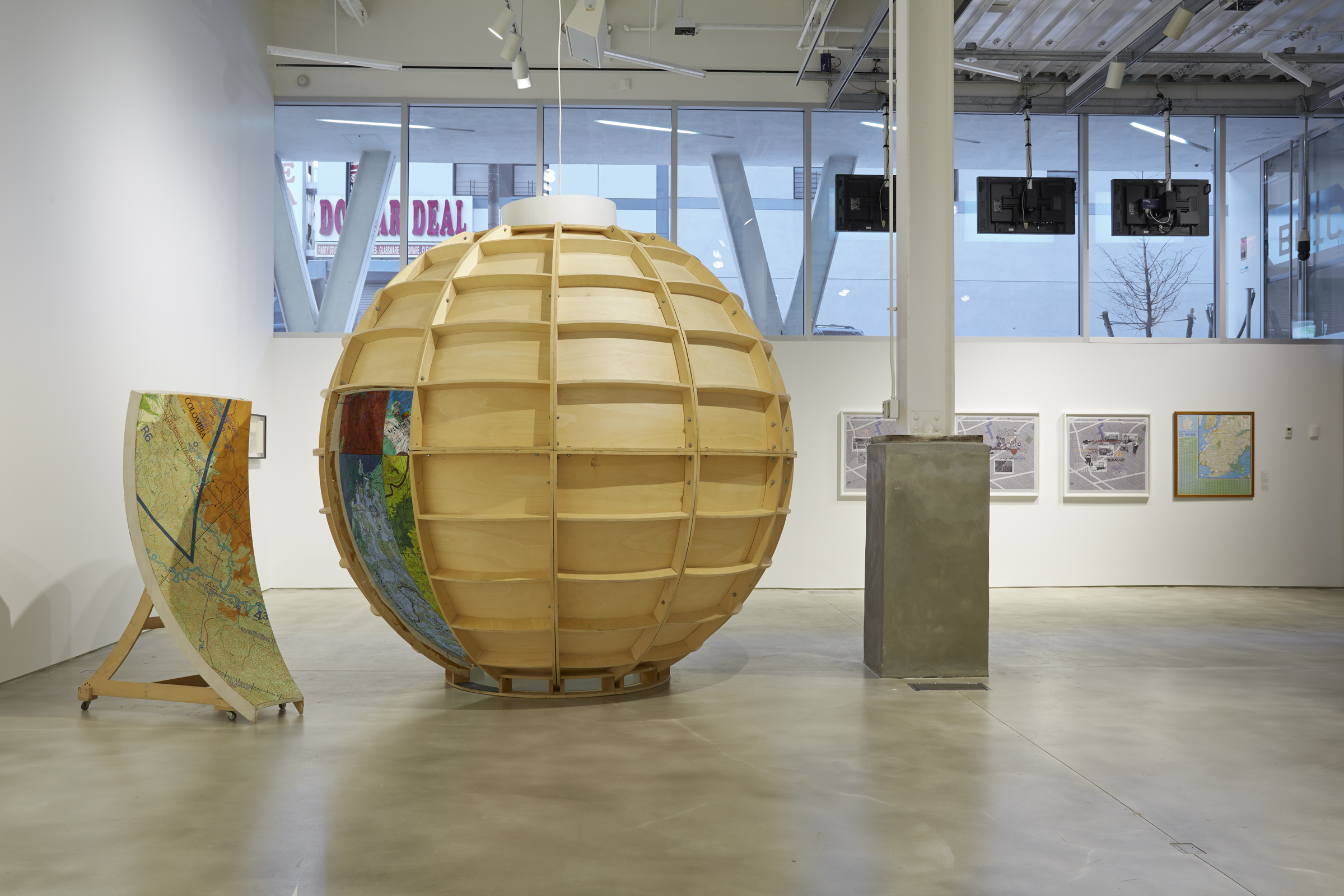
The historic maps in the exhibition will all be drawn from the Brooklyn Historical Society’s collection which boasts one of the richest collections of maps of Brooklyn in the world. There are demographic maps, fire insurance maps and more. Works by contemporary artists will range widely in scale and medium, and will include painting, photography, drawing, sculpture, installations, interactive projects, and appropriated and manipulated historic and contemporary documents. The exhibition includes a monumentally scaled map of Brooklyn by Jennifer Maravillas, made from paper litter collected on epic walks through every block in the borough; a nine-foot diameter walk-in globe painted with aerial maps of sites involved in U.S. military warfare, by Joyce Kozloff; a special project by Amsterdam-based artist Jan Rothuizen,who will retrace the stepsa 17th-century Dutch explorer laid years ago and document his modern-day journey with a series of drawings of people and places in contemporary Brooklyn; and digitized maps that study such phenomena as human emotions as tracked and mapped by Foursquare and created by data visualization designer and geographer Sarah Williams, among other works.
ARTISTS: Aaron Beebe, Daniel Bejar, Francisca Benitez, Gail Biederman, Justin Blinder, Christine Gedeon, Katarina Jerinic, Joyce Kozloff, Laura Kurgan, Peter Lapsley, Jennifer Maravillas, Simonetta Moro, Bundith Phunsombatlert, Jan Rothuizen, Patricia Smith, Nick Vaughan & Jake Margolin, and Sarah Williams.
Please note:
The Mapping Brooklyn exhibition spans the galleries of both BRIC House and the Brooklyn Historical Society. The show will be on view at the Brooklyn Historical Society from Feb 26-Sept 6, 2015. Brooklyn Historical Society is located at 128 Pierrepont Street in Brooklyn Heights. For more information, visit www.brooklynhistory.org.
BK Live 3/5/15: Mapping BK Artist from Brooklyn Independent Media on Vimeo.
BK Live 2/24/15: Mapping Brooklyn from Brooklyn Independent Media on Vimeo.
Special thanks to generous support for this exhibition by Leslie Alexander, Leslie & Cliff Cohen, Katherine & Luke Fichthorn, Julia Kahr & Brian Colton, Kerry Le Blanc Strong & Jeff Strong, and Gaston Silva/Vornado Realty Trust.
This exhibition is supported as part of the Dutch Culture USA program by the Consulate General of the Netherlands in New York.